Be there or be square –
PLEASE ATTEND!!
We need you there!***Pacific Connector Hearing in Coos County – May 20th 2010***
4:00 p.m.
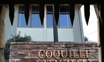
Rally Outside from 3 – 4 p.m.The Hearing will take place in the Planning Department Conference Room of the Coos County Courthouse Annex, 201 N. Adams, Coquille, Oregon.
PLEASE MAKE PLANS TO ATTEND!
Testimony will be accepted up until the close of the hearing……
Come even if you have to be late……
———————————————————-We need people to come and let the Hearings Officer know about what kinds of impacts this pipeline will have to our area. This is one of the FINAL opportunities to let your voices be known!
We need to state the issues and the impacts of this Pipeline:
* Impacts to rural neighboring residences,
* Impacts to nearby farming operations
* Impacts to forestry operations and neighboring forestry operations
* Impacts to public lands (Most if not all of the BLM lands the pipeline goes through are Coos Bay Wagon Road Grant Lands whose timber sales go into the County Coffers)
* Impacts to the estuary and watershed
* Impacts to fishing interests, oyster harvesting, etc.
* Impacts to natural habitats, marine and wildlife
* Impacts to Cultural Resources and Archeological Sites
* Landslide issues and impacts
* Stormwater runoff issues and impacts
* Additional Fire Hazard Impacts – Including increased risk of fire, cost for fire suppression and increased risk to firefighting personnel
* Construction Impacts due to the short-term (“temporary”) loss of the whole 95 feet, as well as the long-term loss of the 50-foot Right of Way, and also the other construction impacts (i.e., trucks blocking the roads used for farm operations for x number of days, weeks, or months, while pipeline is installed, etc.).
* Monitoring Impacts and costs……We need people documenting ALL the impacts of the pipeline. (See a Critera list below that this application must meet)
If you turn in written testimony you will need to turn in 7 copies (Your original and 6 copies for a total of 7 copies altogether) If the Planning Dept has to make copies for you they will charge you .50 per copy.
Additional Information on this application is available at: http://www.co.coos.or.us/Planning/public_info/PCGP.html
A copy of today’s Agenda is below …………
—————————————————-
***A Rundown on the Pacific Connector Pipeline***
The Pacific Connector Gas Pipeline (PCGP) is an approximately 234 mile, 36-inch high-pressure gas pipeline operating at 1,440 PSI (pounds per square inch). PCGP is proposed to transport 1 billion cubic feet a day of gas from the Coos Bay LNG site to a connect at Malin, Oregon in an effort to supply California ( Pacific Gas and Electric ) rate payers with costly foreign energy. The Hazard zone for this pipeline is approximately a 900 ft circumference from the center of the pipe[1] (1,800 feet across) which impacts many landowners who may not even be aware they are living or have property in a pipeline hazard zone.
The Coos County conditional use application includes 49.7 miles of the Pacific Connector gas pipeline and will connect the Jordan Cove liquefied natural gas (LNG) terminal on the north spit of Coos Bay with the Douglas County portion of the pipeline.
Pacific Connector Pipeline Project Areas within Coos County Zoning Designations:
Forest (F) – 39.47 miles
Exclusive Farm Use (EFU) – 3.72 miles
Rural Residential-5 – 0.37 miles
Rural Residential-2 – 0.10 miles
Industrial – 0.07 miles
Coos Bay Estuary Management Plan (all zones) – 5.99 miles
Total 49.72 miles1 mile = 5,280 feet / 39.47 miles Forest Lands X 5,280 feet = 208,401.6 feet
208,401.6 feet X 50-foot wide permanent right of way = 10,420,080 square feet of timber land taken out of production in Coos County alone.
Pacific Connector Overall Waterbody Impacts:
NOTE: The Final EIS page 4.5-84 stated impacts to waterbodies that were different from Pacific Connector’s Clean Water Permit Application that was submitted to Army Corps in May 2009.
Final EIS Page 4.5-84 Stated the following:
“The Pacific Connector’s pipeline would cross or affect 249 waterbodies (excluding ditches): 111 perennial streams, 131 intermittent streams, 4 stock ponds, 1 excavated pond, 1 industrial pond, 1 natural pond, and Coos Bay (1 crossing). Available data indicate that about 123 of these waterbodies are known (59) or assumed (64) to be inhabited by fish.” (Final EIS Page 4.5-84)
(Note: Draft EIS had stated 379 waterbodies would be impacted)
Pacific Connector Clean Water Permit Application
Appendix F – Affected Water Resources – Page 4 stated:“The PCGP Project will affect 383 waterbodies in 18 of the 19 Fifth Field Watersheds. Of the 383 waterbodies affected, 104 are perennial, 128 are intermittent, 143 are ditches, 7 are stock ponds, and 1 estuary (Haynes Inlet in the Coos Bay Estuary).
In Coos County, the PCGP Project will affect 59 perennial and 28 intermittent waterbodies, 14 ditches, 1 stock pond, and 1 estuary….” (Emphasis added)Pacific Connector Clean Water Permit Application
Appendix I – Wetland Mitigation PCGP – Page 1 stated:“The project will cross 383 waterbodies, of which 104 are perennial, 128 are intermittent, 143 are ditches, 7 are stock ponds and 1 estuary (Haynes Inlet in the Coos Bay Estuary) as indicated in Table 2A-2 in Appendix A. Available data indicates 64 of the waterbodies (including the Coos Bay Estuary) are known to support fish (fish-bearing) and 62 more are presumed to be inhabited, based on annual flow regimes and connectivity to documented fish-bearing streams, 90 are unknown and 23 are not fish bearing.” (Emphasis added)
The freshwater streams crossed by proposed pipeline route include 6 major subbasins of rivers in southern Oregon, the Coos, Coquille, South Umpqua, Upper Rogue, Upper Klamath and Lost River subasins. Most of the major streams, and many of the minor streams crossed contain salmon and steelhead, some of which are federally listed as threatened fish species.
Construction of the Pacific Connector pipeline would affect about 3,035 acres of forest and woodland, 623 acres of agricultural lands, 488 acres of grasslands-shrubland, and 131 acres of non- riparian vegetation. (Final EIS page 5-9). ( I am not sure if these statistics also include the temporary roads and staging areas that will be needed by the Pipeline company)
Approximately 151 miles, or 66 percent, of the proposed pipeline route would cross private property, which could be taken by eminent domain. The remaining 79 miles (34 percent) of pipeline route would cross public lands administered by the BLM (18 percent), USFS (12 percent), BOR (0.14 percent), (Final EIS page 4.8-25)
The Pacific Connector is slated to directly impact Clausen Oyster Company’s best oyster beds. Clausen Oyster Co, the former Kentuck Golf Course, and Coos County Sheep Farm are just a few businesses in the Coos Bay area that will be negatively impacted by the pipeline.
The Pacific Connector proposes to use a 95-foot-wide standard construction right-of-way for the pipeline. (Final EIS Page 2-61) On federally managed lands, Pacific Connector proposes to acquire a 53-foot-wide permanent easement, centered over the pipe. On private timberlands, Pacific Connector proposes to acquire a 60-foot-wide permanent easement. On all other private lands, Pacific Connector proposes to acquire a 75-foot-wide permanent easement (Final EIS Page 2-64 –2-65). The Federal Energy Regulatory Commission is not allowing the use of eminent domain on an easement that will exceed 50 feet (Final EIS Page 2-66). Landowners could be given less money for use of land due to smaller easements and there is no compensation listed for hazard zone property value devaluation. Vegetation at above ground facilities would be periodically maintained using mowing, cutting, trimming and the selective use of herbicides (Final EIS Page 2-110). Herbicides could affect native plant species, thereby affecting wildlife habitat and potentially the animals themselves (Final EIS Page 4.5-32).
[1] GRI-00/0189 / C-FER Report 99068, “ A Model for Sizing High Consequence Areas Associated with Natural Gas Pipelines” Topical Report prepared by Mark J Stephens, C-FER Technologies, for Gas Research Institute, Contract No 8174, Oct 2000
——————————————————————–
NOTE: The Pacific Connector Gas Pipeline states in their Coos County Application that they will only obtain a 50-foot wide permanent right of way.
——————————————————————–
The hearings officer will be explaining all procedures including any time limit that he may have. This agenda below is just a general outline.
http://www.co.coos.or.us/Planning/2010_NoticesAgendas/05-20-10_Planning_Agenda_for_Pipeline.pdfCoos County Planning Department 201 N. Adams, Coquille, Oregon
Agenda
May 20, 2010
For Coos County File # HBCU-10-01
Welcome to the Coos County Land Use Hearing
This is a hearing request for a conditional use approval to allow a 49.7-mile natural gas pipeline connecting the Jordan Cove liquefied natural gas (LNG) terminal on the north spit of Coos Bay with the Douglas County portion of the pipeline. The pipeline will be below ground, but will require a 50-foot permanent right of way and four above-ground block valves. The pipeline will cross through the Rural Residential (RR-5 & RR-2), Exclusive Farm Use (EFU), Forest (F) and Industrial (IND) zones, as well as 15 separate Coos Bay Estuary Management Plan (CBEMP) zoning districts. The applicant is Pacific Connector Gas Pipeline Company
I. Call Meeting to order at 4:00 p.m.
II. Procedural Matters
III. Staff Presentation of Item
IV. Arguments
a. Applicant’s Presentation
b. Proponents
c. Opponents
d. Neutral Parties
e. Applicant’s Rebuttal
V. Final instruction from the Hearing’s Officer
There will be breaks approximately every two hours for fifteen minutes at a time. If required by time constraints the hearing may be continued to a date and time certain by the Hearings Officer.
This hearing is governed by Coos County Zoning and Land Development Ordinance (LDO) §5.7.300. This is a quasi-judicial land use hearing. Thus, failure to raise an issue in person or in writing, or failure to provide statements or evidence sufficient to afford the decision maker an opportunity to respond to the issue precludes appeal to the Land Use Board of Appeals based on that issue.
Please see attached for the list of the applicable criteria that should be addressed in your testimony. You can find the criteria by visiting the Coos County Planning Department in person at 225 N. Adams Street, Coquille OR 97423 or visiting our website at http://www.co.coos.or.us/Planning/CCZLDO/toc.htm .
If you are presenting oral testimony, please complete a “Request to Speak” form and give it to the staff prior to the hearing. At the time of your oral presentation, you will need to state your name and mailing address for the record. Testimony must be specifically related to the applicable criteria. Any testimony outside the scope of the hearing will not be considered. The Hearing Officer will not receive redundant testimony. You should endorse, rather than repeat prior testimony of others which you agree with.
CRITERIA
The application must meet criteria set forth in the Coos County Zoning and Land Development Ordinance
(CCZLDO) as follows:
Section 2.1.200 Specific Definitions
Section 3.1.150 Building Permit Issuance
Section 3.1.200 Verification Letter Required for Building Permit
Section 3.2.200 Uses Listed as Permitted
Section 3.2.250 Administrative Conditional Use
Section 3.2.300 Hearings Body Conditional Use
Section 3.2.500 Right of Way Enhancement
Section 3.2.700 Process for Tribe(s) Review of Development Within Archaeological Sites
Section 3.3.100 Lot Standards
Section 4.1.100 Establishment of Zoning Districts
Section 4.2.100 Use Matrices
Section 4.2.400 Rural Residential Zoning Districts
Section 4.2.600 Commercial-Industrial Zoning Districts
Section 4.2.900 Review Standards and Special Development Conditions
Section 4.4.400 General Standards for Rural Residential Zoning Districts
Section 4.4.600 General Standards for Commercial-Industrial Zoning Districts
Section 4.5.100 CBEMP Zoning Districts – Purpose and Standards
Section 4.5.150 How to Use This Article
Section 4.5.175 Site-Specific Zoning Districts
Section 4.5.180 Riparian Protection Standards in the CBEMP
Section 4.5.275 Management Objective for District 6-WD
Section 4.5.276 Uses, Activities and Special Conditions for District 6-WD
Section 4.5.285 Management Objective for District 7-D
Section 4.5.286 Uses, Activities and Special Conditions for District 7-D
Section 4.5.370 Management Objective for District 8-D
Section 4.5.371 Uses, Activities and Special Conditions for District 8-D
Section 4.5.375 Management Objective for District 8-CA
Section 4.5.376 Uses, Activities and Special Conditions for District 8-CA
Section 4.5.405 Management Objective for District 11-NA
Section 4.5.406 Uses, Activities and Special Conditions for District 11-NA
Section 4.5.400 Management Objective for District 11-RS
Section 4.5.401 Uses, Activities and Special Conditions for District 11-RS
Section 4.5.425 Management Objective for District 13A-NA
Section 4.5.426 Uses, Activities and Special Conditions for District 13A-NA
Section 4.5.480 Management Objective for District 18-RS
Section 4.5.481 Uses, Activities and Special Conditions for District 18-RS
Section 4.5.535 Management Objective for District 19-D
Section 4.5.536 Uses, Activities and Special Conditions for District 19-D
Section 4.5.540 Management Objective for District 19B-DA
Section 4.5.541 Uses, Activities and Special Conditions for District 19B-DA
Section 4.5.550 Management Objective for District 20-CA
Section 4.5.551 Uses, Activities and Special Conditions for District 20-CA
Section 4.5.545 Management Objective for District 20-RS
Section 4.5.546 Uses, Activities and Special Conditions for District 20-RS
Section 4.5.595 Management Objective for District 21-RS
Section 4.5.596 Uses, Activities and Special Conditions for District 21-RS
Section 4.5.600 Management Objective for District 21-CA
Section 4.5.601 Uses, Activities and Special Conditions for District 21-CA
Section 4.5.690 Management Objective for District 36-UW
Section 4.5.691 Uses, Activities and Special Conditions for District 36-UW
Section 4.6.205 Designation of Flood Areas
Section 4.6.220 Identification of Flood Hazard Areas on Verification Letter
Section 4.6.230 Procedural Requirements for Development in Flood Hazard Areas
Section 4.6.235 Sites Within Special Flood Hazard Areas
Section 4.7.105 Special Considerations – Prescribed Regulations
Section 4.8.300 Administrative Conditional Uses
Section 4.8.400 Review Criteria for Conditional Uses in Section 4.8.300
Section 4.8.600 Mandatory Siting Standards for Dwellings and Structures in the Forest Zone
Section 4.8.700 Fire Siting and Safety Standards
Section 4.8.750 Development Standards
Section 4.9.450 Additional Hearings Body Conditional Uses and Review Criteria
Section 4.9.600 Siting Standards for Dwellings and Structures in the EFU Zone
Section 4.9.700 Development Standards
Article 5.0 Administration and Application Review Provisions
Article 5.2 Conditional Uses
Article 5.7 Notice and Public Hearings
Appendix 3, Volume II – CBEMP Policies 14, 16, 17, 18, 20, 22, 23, 27, 28, 30, 34, 49, 50, 51
—————————————————-